Development of a Smart Quadcopter Network for Urban Security,
Environmental Monitoring, and Development
Project Overview
NgDroneNet: a Smart Drone Network for Urban Security, Environmental Monitoring, and Development
Security problems are now an apparently unavoidable fact of life in Nigeria. Insurgency is rampant in some parts of the country, while kidnapping and other crimes are on the increase in other parts. Such security problems harm the economy in multiple ways. They discourage foreign investment and are a major factor in the accelerating human capital flight as many young professionals emigrate. Finally, they lead to incalculable losses in terms of lives, livelihoods and properties.
A major contributor to this spiraling security situation is the lack of situational awareness structures for the nation’s security agencies. This same lack of situational awareness results in challenges in other sectors of the economy. Intelligent transportation systems, environmental monitoring, and disaster response are a few other sectors that would benefit from functional situational awareness frameworks.
The potential of sensor-equipped Unmanned Aerial Vehicles (UAVs) to gather information-rich data over a vast region and their high mobility makes them attractive in comparison with traditional approaches used in situational awareness.
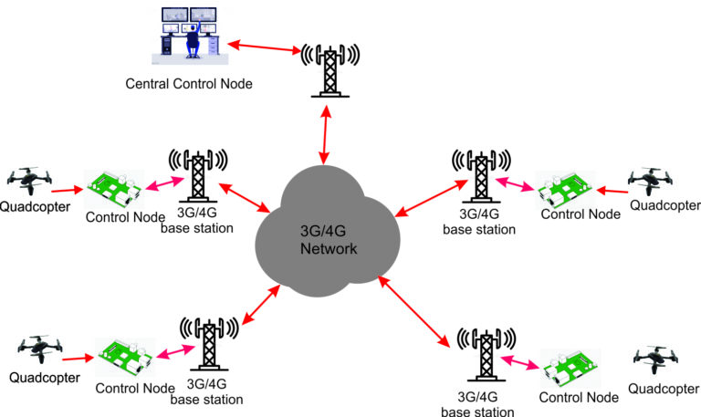
However, getting the right trade-off of UAV features is challenging. The best situational awareness trade-off scenarios use large numbers of drones, which necessitates low-cost UAVs such as small four-motor UAVs called quadcopters. Such quadcopters however have short flight times. There is therefore a need for a system that allows the extension of cumulative flight time for quadcopters while deploying them for intelligent situational awareness functions. This research will develop a quadcopter network consisting of low-cost sensor-equipped quadcopters and control nodes to tackle the lack of low-cost situational awareness infrastructures for security, environmental and planning uses.
The network will consist of a number of control nodes. Each control node will control the flight pattern of a
quadcopter assigned to its area without any human intervention, determine when the quadcopter should be recharged, and guide the landing and docking of the quadcopter. Through a radio communication link, each quadcopter will relay video data obtained through its camera to the control node which will then be forwarded to the Central Control Node through a 3G cellular network.The Central Control Node will run an artificial intelligence-
based monitoring and control software that will extract events of interest from the information-rich data obtained from the quadcopters through their respective control nodes.
The performance of the network will be evaluated with metrics such as Mahalanobi’s distance metric for appraising object tracking abilities and standard machine learning metrics including accuracy and precision.
The 5th Applied Artificial Intelligence and Robotics Laboratory Seminar showcased a presentation centered around the curation of the Nigerian Schizophrenia ...